

Dedicated to promoting the discovery and preservation of the rich history of the people, events, and places that make up Wisconsin's Last Wilderness.

Chronologies of the Township of Presque Isle History.
2,580,000BP First advance of glaciers across North American continent.
t.
25,000BP Beginning of Last (Wisconsinan) glacial era.
era.
8,000BP Retreat of last ice sheets, leaving lakes and Winegar Moraine.
bb
6,000BP Archaic Indians occupy the North Woods; fishing, hunting and gathering.
ing.
1,000BP Menominee Indians migrate into the North Woods displacing Woodland Indians.
Indians.
1600’s Presque Isle is French for “almost an island”, named by two French priests coming through Lake Superior on a missionary expedition. After a shipwreck, they pitched camp at a mouth of a river and survived the winter. Come spring, water levels were so high that they found themselves on “almost an island”. They named the river Presque Isle which flows into Lake Superior. Much later as explorers, they traveled upstream (which is south) along the south branch of the Presque Isle River to its headwaters, and found a large lake that they named Presque Isle Lake.
123
1700’s Ojibwa Indians drive out rival Fox and Dakota tribes
6
1784 The territory eventually became Wisconsin which was ceded to the US by the state of Virginia.
123
1787 Future Wisconsin lands were designated part of the Northwest Territory of the US.
123
1800 As states were formed, lands within area that become Wisconsin were now part of area designated the Indiana Territory.
123
1800 Wisconsin lands considered part of the Michigan Territory.
123
1833 Federal survey of public lands begins.

Chronicle of Heritage.
Establishment of Wisconsin.
1836 May 20, Territory of Wisconsin was established by separation from what then was the state of Michigan.
The new territory initially included all of the present day states of Wisconsin, Minnesota, and Iowa, as well as parts of North and South Dakota (figure on right).
mid-
1840's The population of the territory exceeded 150,000; more than twice the number required for establishing statehood.
By
1848 May 29, a referendum was held in which the residents of the territory approved a state constitution, orders were adjusted and Wisconsin became the 30th state.

The earliest Wisconsin settlements by non-native Americans were centered around military forts and trading outposts which were located along the Lake Michigan and Lake Superior shorelines and navigable rivers such as; the Mississippi, the Wisconsin, the Chippewa, the Rock, and the Fox. Miners, farmers, and tradesmen pushed into southern and central portions of the state.
123
1850's railroad companies were competing to expand operations, further accelerating development. With land covered by extensive forests, lakes, and marshlands; poorer soils and harsher climates; and fewer marketable resources the northern portions of Wisconsin were slower to be settled.
123
Logging began in the Northwoods region in the late 1850's along the tributaries of the Wisconsin River in areas such as Eagle River, Rhinelander, and Tomahawk, with logs (predominately White Pine) being floated downstream to Sawmills in Merrill, Wausau and Stevens Point. Migrants from New England came to the Northwoods and trails and wagon roads were constructed through what is now Vilas County to supply the earliest settlers and the logging camps. Early routes included the Ontonagon Mail Trail (which ran from Wausau to Ontonagon MI), State Line Road (Wausau to Lac Vieux Desert), and the Military Road which ran from Fort Howard (Green Bay) to Fort Wilkins (Copper Harbor, Michigan).
123
1863 Survey of Presque Isle Township accepted by General Land Office
Political Boundaries.
Top of page.
1865 On the map of Wisconsin to the right shows the political (county) boundaries at the end of the Civil War, large expanses of the Northwoods were still sparsely populated and had not been subdivided into locally administered counties. Marathon County (now centered on Wausau) extended roughly half the height of the state, including areas now recognized as Lincoln, Oneida, and Vilas counties.
123
1870 Billion board feet Norway Pine, White Pine, & Hemlock in upper Wisconsin River including what will become Vilas County.
123
1871 November 08, the greatest forest fire in American history destroys Peshtigo (Menominee County) Wisconsin with 800 to 1200 lives lost. (Same day as the great Chicago fire.)

Original Land Survey.
1833 to 1866 The federal government surveyed the land area now known as the State of Wisconsin. The survey was done to divide the area into lots that were of a size that could be sold or otherwise divested; raising funds for the government and encouraging settlement of the vast frontier lands. This original survey is commonly referred to as the Public Land Survey and it was done using the Public Land Survey System (PLSS) which divides land into six-mile square Civil Towns and one-mile square sections. Under the PLSS, Presque Isle falls within four townships which contain (all or parts of) 83 sections.

Hover over the above figure, and your cursor will turn into a magnifier.
1860 to 1863 The fieldwork for the original survey of the area covered by the Civil Town of Presque Isle was done between 1860 and 1862. The final compiled surveys were accepted by the General Land Office in April 1863. The figure below shows the original survey of the township described as T43 North - R06 East, which contains recognizable landmarks such as Presque Isle Lake, Crab Lake, Horsehead Lakes & Armour Lake, and the creeks that connect them.
Click the figure to the right to download a large .pdf version.
Hover over the figure to the right and your cursor will turn into a magnifier.

When surveyors were establishing their North-South or East-West lines across solid land, they documented the corners of each township and section with field markers. When they encountered obstacles such as lakes or large rivers they set posts at the shoreline. They then surveyed along the shoreline using these meander posts, allowing them to reestablish the base survey line on the opposite side of the lake or river. These surveyed meander posts were all part of the original record and became the basis for demarcating the government lots that were subsequently sold and subdivided into the lakeshore lots we recognize today. A series of subsequent surveys were conducted in 1908 to formally document the larger islands in many of the lakes of the Civil Town of Presque Isle.
123
1865 Marathon County extends to Michigan border; includes the Civil Town of Presque Isle.
Private Ownership of Land – Original Purchases.
1871 When Congress established the Wisconsin Territory in 1836 all land in the territory was owned by the Federal Government. Under the Land Act of 1820, this federally owned land could be purchased for $1.25 per acre and squatters could purchase land even more cheaply if they occupied and made improvements to the land, such as building homes, fences, or mills. The earliest recorded purchases of private land in the Civil Town of Presque Isle appears to have been made in 1871. On 1 April of that year, Emma Ripley of Saginaw County Michigan made three cash transactions at the Land Office in Stevens Point in which she took possession of 315.84 acres of land in the southwest portion of the Civil Town of Presque Isle. Most of this land was on, or near-by Big Lake (figure) while the remainder was to the south of Crab Lake. Three weeks later she was involved in four additional purchases of land in the southwestern Civil Town of Presque Isle, though on these sales she was listed as a co-owner. Land in the Civil Town of Presque Isle continued to be sold in variously sized lots through the 1870's.
Copy of Elliott and Giles Slocum's purchase Deed from Land Sale in the Civil Town of Presque Isle (1871).


Location of four (4) lots (116.9 acres) purchased by Emma Ripley on April 1, 1871.

Top of page.
1883 C&N-W Ry arrived eastern Vilas Co. (Eagle River - Conover - Land O’ Lakes). Train were primarily for shipping lumber to markets, but passenger trains brought more and more fishermen, hunters and families of summer tourist. First resorts are established.
s.
Beginning in 1883 out-of-area investors from Michigan and downstate Wisconsin began buying very large tracts of land and in less than six years four wealthy investors bought up over 61% of the land in the Civil Town of Presque Isle (table below). Access to the remote regions of the North Woods was improving as railroads expanded their networks and the power and scale of their equipment. These investors knew that the large, untapped expanses of forests that remained in the Civil Town of Presque Isle and throughout the neighboring counties were likely to bring strong returns as the nation’s towns and cities and the demand for building materials such as lumber continued to grow. It was to be about 20 years before these land holdings were consolidated by the Vilas County Lumber Company which built its Sawmill which began operations in 1905. The largest investments were made by a pair of men named Elliott and Giles Slocum (shown above) who hailed from Wayne County, Michigan (see table below). Between September 1883 and January 1885 they bought up almost a quarter of the entire township. All of these sales were made out of the Wausau Land Office and the original sale documents, referred to a Surveyor General Patents, are on-line and still searchable by the public.
Original Sales of Major Land Purchases of US Government Lands, 1883 to 1889.

1885 C&N-W Ry entered SW corner of Vilas County.
[1] In
1893 Vilas County was established as a Wisconsin county, having been set apart from Oneida County. When set off, Vilas County contained two towns - Eagle River and Minocqua. Additional towns were created in the ensuing years.
1894 First train arrived Mercer. (Stories of coming north by train include the entire household and live stock in the same box car. Some families lived in Box Cars for quite some time.)
1896 First vacation home on Crab Lake.
Property ownership brought privileges. In the same way that John J. Foster and William S. Winegar were to name their Sawmill towns Fosterville and Winegar, local landowners put their personal stamp on local landmarks. Elliot and Giles Slocum managed to have the lake we now know as Horsehead Lake named Slocum Lake in their day. On an 1898 map of Oneida and Vilas Counties (figure) we see that several Presque Isle lakes had different names than what we recognize now.
1898
-
Horsehead was named Slocum Lake
-
Armour was Margaret Dwier Lake
-
Round was Copp Lake
-
Carlin was Keno Lake
-
Annabelle was Foulks Lake
-
Stateline was Shepard Lake
-
Papoose was Pipe Lake
-
Oxbow was Elliott Lake
-
Lynx was Henry Casson Lake
-
Flora was Ferris Lake

Older version of 1898 Map of Oneida, Vilas AND RANGE 4 OF IRON COUNTIES WISCONSIN.
In an updated Plat Book published in 1908 many of the lakes carried the names we use today. By this time the Vilas County Lumber Company was well into operation and the population and activity in the area had grown very significantly from 10 years prior. The lumber company was conducting cutting operations and was doing timber inventories and assessing future routes for the rail spurs they would build into un-cut lands. Thus, the 1908 publication was much more accurate with detailed locations and outlines of lakes and streams and some roads. Errors were still made in the compilation of these plat maps; while Katinka Lake was now named on the map of T43N R06E, the name fell on what we know to be Carlin Lake and the body of water we now call Katinka was still missing from the below plot.
Incorrect location of Carlin Lake.

Newer version with errors and omissions of 1898 Map of Oneida, Vilas AND RANGE 4 OF IRON COUNTIES WISCONSIN.

True location of Katinka Lake.
True location of Carlin Lake.
1962 Plat Book.
1900 4,929 population of Vilas County.
Top of page.
Click the above photo for biographies of a few of the first residents of Presque Isle, Wisconsin.

1903 January, 07 the first town named Presque Isle was formed. (Located on what is now County Road “W” about 3 miles west of the modern town of Presque Isle.)
123
1904 Vilas County Lumber Company (VCLCo) established. Chicago & North-Western Railway builds spur from Mercer to Fosterville; freight & passenger service.
123
1905 VCLCo builds sawmill & a Company Town. Begins logging & lumbering operations. J. J. Foster (President of the VCLCo.) names Company Town, Fosterville. Large fire in the fall wipes out major portions of the town of Fosterville, leaving depot and one home.
123
1906 Recreation Hall, Post Office and first School opened in Fosterville.
123
1907 The Civil Town of Presque Isle was created. The adjacent Civil Town of Land ’O Lakes (originally called State Line) was also created. When the Civil Town of Presque Isle was created in 1907, it already contained the newly established (1905) Vilas County Lumber Company which was originally operated by J. J. Foster. The lumber company had built a large Sawmill operation and camps in the pines to fell local trees.
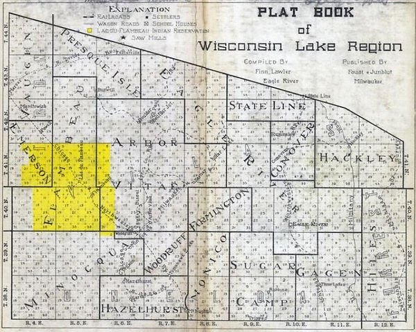
1908 PLATT BOOK of Wisconsin Lake Region (to the right) shows the extent of the Civil Town of Presque Isle and both the villages of Divide and Fosterville in northwestern portion of Vilas County just south of the state boundary with Michigan. John J. Foster named the town Fosterville. Fosterville was a Company Town to house the workers of the Sawmill and supply the logging camps. The name Fosterville was carried until John turned over operation to another compa- ny investor, William S. Winegar.
Hover over the above figure, and your cursor will turn into a magnifier.

First frame home on Horse Head Lake.
1910 William S. Winegar succeeded J. J. Foster as President of VCLCo. W. S. Winegar subsequently renamed the town after himself and the town was called Winegar until 1955 when it adopted by voice vote the same name as the Civil Town - "Presque Isle". Census enumerates 833 persons in the Civil Town of Presque Isle.
123
1911 Town Hall rebuilt over the Pool Hall.
123
1914 Second two-room School house built in Winegar.
123
1916 Chicago &NW Ry has daily service between Mercer & Winegar.
123
1920 Census enumerates 983 persons in Presque Isle Township.
123
1920’s Winegar expands to 2000 residents.
123
1921 The Civil Town of Presque Isle initially included an area that was subsequently separated and became the Civil Town of Winchester.
123
1923 May 5, the original town of Presque Isle dissolved.
1924 Another plat book of Vilas County was prepared in about 1924. By this time roads we know as Hwy W and B had been constructed and were shown, although no town or local roads were rendered. Land ownership of large tracts was included on these maps with lumber interests such as Vilas County Lumber Co., CF Dunbar, Brooks & Ross Lumber Co., and Bushwell Lumber & Mfg Co., owning much of the land. It is also clear that by the early 1920's the State of Wisconsin had started acquiring lands that were to become part of the Northern Highland-American Legion State Forest. Note; apparently little field mapping was conducted in preparing this volume; Katinka Lake is still missing and Carlin Lake is still mislabeled as Katinka.


Above figures are from a 1924 Plat Book.
1924 School built in what was Presque Isle, 3 miles west of Winegar.
123
1925 Northern Highland State Forest established in Vilas County, largest national forest in the United States at the time.
123
1926 W. S. Winegar sold VCLCo to Wm. Bonifas and Joseph Gorman.
123
1927 Boulder Junction and Manitowish Waters (originally called Star Lake) were created.
123
1930 Census enumerates 539 persons in the Civil Town of Presque Isle.
123
1933 Bonifas-Gorman Lumber Company sold. Sawmill frame dismantled and moved to Lake Linden, Michigan.
123
1936 Rail service to Winegar ends; Winegar population falls to 100.
123
1939 Presque Isle State Graded School built by the WPA in Winegar.
123
1946 American Legion Winegar Post 480 established.
123
1947 Heinke Sawmill on Presque Isle Lake.
123
1950’s Chamber of Commerce formed; post-war resort boom.
123
1955 Winegar renamed Presque Isle by voice vote of residents.
123
1959 Civil Town Zoning, first in county, insures protective waterfront development.
123
1966 Snowmobile trails developed, Sno-Bunnies Club formed, local ski trails operate.
123
1970’s Annual Country Fair & “Wisconsin’s Last Wilderness” inaugurated by Chamber.
123
1972 Presque Isle Lions Club formed.
1980 Presque Isle Heritage Society organized.
123
1993 Preaque Isle Graded School listed on National & State Historic Register.
123
1995 Presque Isle Graded School replaced with new Community Center housing town office, library.
123
2000 Census enumerates 513 people in the Civil Town of Presque Isle. Catherine Wolter Wilderness Area formed & managed by The Nature Conservancy.
123
2013 Van Vliet Hemlocks State Natural Area designated.
123
2015 Pipke Park formed on site of VCLCo mill pond & Walleye rearing ponds.
123
2018 Wilderness Veterans Memorial Flame built & inaugurated.
Top of page.
Research of early history and Civil Town of Presque Isle Maps and Plat Books courtesy of Eric R. Benn.